01
Identify the Model Gap
Your team defines the environment, interaction, viewpoint, sensor condition, or failure scenario that existing data does not represent well.
Real-World & Multimodal Data Engineering
Origin Data Lab designs and operates managed real-world and multimodal field-data programs for Physical AI, robotics, computer vision, and intelligent systems.
Define the environment, interaction, viewpoint, metadata, and quality criteria your team needs. Rather than asking you to choose from a fixed catalog, we translate those requirements into a practical capture and delivery plan.
A short description of the missing data condition is enough to begin an initial feasibility review.
From Model Gap to Field Data
Each engagement begins with a specific model weakness or missing real-world condition. We convert that requirement into a controlled field-production program and a technically reviewable delivery package.
01
Your team defines the environment, interaction, viewpoint, sensor condition, or failure scenario that existing data does not represent well.
02
We turn the requirement into executable field missions, including target conditions, capture method, operator instructions, and expected evidence.
03
Trained local operators execute missions through our dedicated field-data application, which records capture context, timestamps, GPS tracks, IMU signals, device information, and upload traceability.
04
Captures are technically reviewed, connected to structured metadata, assigned stable identifiers, and packaged for parsing, ingestion testing, and engineering evaluation.
MP4 video segments, segment-level JSON metadata, manifests, schema documentation, validation records, identifier mapping, and technical delivery notes.
Technical Scope Definition
Before collection begins, we document the capture conditions, metadata schema, acceptance rules, and delivery structure that will govern the PoC.
01
Define the real-world conditions that must be represented and how they will be captured.
02
Define the machine-readable fields, identifiers, and relationships required by your engineering pipeline.
03
Define the technical conditions each capture and delivery package must satisfy before release.
Operating Production Infrastructure
Our production system is already used to coordinate field operators, preserve file lineage, detect incomplete or low-value captures, and route failed records into review or recollection.
01
Each collection task can define the target workflow, environment, capture method, minimum duration, required actions, sensor configuration, camera orientation, and recording instructions before capture begins.
02
Video, capture metadata, IMU records, upload status, source identifiers, processed segments, and final delivery assets remain linked through the production lifecycle.
03
Technical warnings and quality outcomes are retained as explicit approval, review, rejection, or recollection records rather than informal manual notes.
04
Incomplete uploads, missing metadata, weak movement, duplicate-risk captures, poor visibility, and other project-defined failures can be identified before delivery and returned for review or replacement capture.
Our operating model combines field access with controlled production. South Korea supports scarce and region-specific workflows across industrial, commercial, food-production, service, and household environments, while Bangladesh provides scalable field operations across diverse real-world settings. The same mission, metadata, QC, traceability, and recollection controls are applied according to project requirements.
Illustrative Physical AI & Real-World Scenarios
Custom collection can be designed around the human actions, object interactions, tools, environments, viewpoints, and sensor conditions that matter to a target Physical AI or robotics system.
These examples are not fixed catalog datasets. They illustrate how project-defined workflows can be translated into executable field missions, metadata requirements, quality rules, and engineering-ready delivery packages.
Swipe horizontally to view full scenario details.
| Field Scenario | Model Gap | Target Interactions | Configurable Conditions | Capture Method | Metadata and Validation Focus | Engineering Use |
|---|---|---|---|---|---|---|
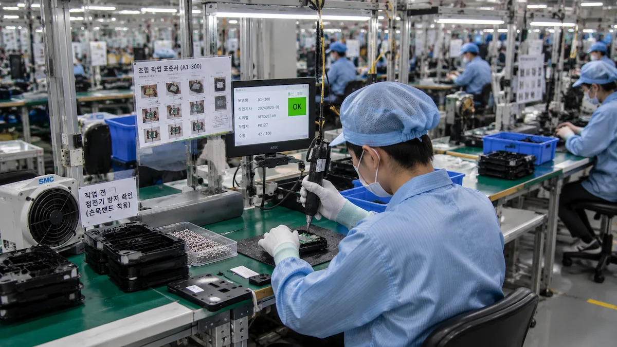
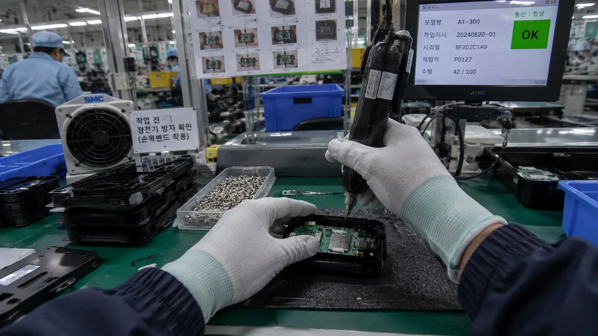
| Precision Electronics Assembly | Limited coverage of fine-grained hand-object interaction, tool use, and multi-step precision tasks | Component handling, fastening, cable connection, inspection, tool switching, and assembly sequences | Workstation type, component mix, task order, operator experience, lighting, and tool configuration | Egocentric head-mounted, chest-mounted, or approved fixed-view capture | Task ID, action stage, object context, timestamps, sensor availability, visibility, and QC status | Manipulation learning, task understanding, robotics evaluation, and workflow modeling |
| Garment & Deformable Materials | Insufficient data for manipulating flexible materials whose shape changes continuously during handling | Fabric alignment, folding, feeding, sewing, repositioning, cutting, and two-handed coordination | Material type, workstation layout, garment stage, tool configuration, task complexity, and operator technique | Egocentric capture or contextual third-person production view | Task progression, hand visibility, material state, action sequence, timestamps, and capture quality | Deformable-object manipulation, human demonstration learning, and industrial robotics |
| Commercial & Service Workflows | Weak representation of real service tasks performed in changing human environments | Housekeeping, cleaning, object placement, surface handling, equipment use, and repeated service routines | Room layout, object arrangement, cleaning state, task order, equipment, lighting, and human activity | First-person or project-defined mobile capture | Workflow stage, environment state, task completion, object interaction, duration, and QC decisions | Service robotics, embodied AI, activity understanding, and task planning |
| Korea-Specific Skilled Workflows | Scarce training coverage of regional, culturally specific, and skilled manual activity | Food preparation, kimchi production, seafood processing, precision cutting, packaging, and specialized commercial tasks | Product type, tool set, preparation stage, environment, operator method, and workflow variation | Egocentric human demonstration with contextual field capture | Task/subtask labels, tool and object context, hand visibility, sequence, metadata, and acceptance criteria | Regional domain expansion, skilled manipulation learning, and Physical AI evaluation |
| Warehouse & Logistics | Limited coverage of real picking, scanning, sorting, and fulfillment workflows | Item identification, barcode scanning, bin selection, picking, carrying, sorting, packing, and placement | SKU mix, shelf height, aisle layout, task sequence, load size, congestion, and device type | Egocentric mobile capture with optional sensor context | Item/task identifiers, timestamps, device context, action completion, movement, and QC status | Mobile manipulation, warehouse robotics, navigation, task planning, and vision-language-action research |
| Real-World Mobility & Long-Tail Environments | Models trained primarily on structured environments with limited coverage of difficult real-world interactions | Pedestrian movement, mixed transport, close-proximity navigation, occlusion, and informal interactions | Geography, crowd density, route, lighting, weather, platform, and movement pattern | Walking, bicycle, motorcycle, vehicle-based, or other approved mobile capture | GPS, IMU, scene context, movement, visibility, timestamps, and quality signals | Autonomous systems, robotics navigation, perception robustness, and long-tail evaluation |
Final geography, workflow, participant profile, viewpoint, capture method, sensor configuration, metadata schema, acceptance criteria, and delivery volume are defined around the customer’s technical objective.
Live Operating Evidence
Our dedicated field-data application and internal review tools coordinate mission-based capture, bundle uploads, sensor and metadata checks, technical quality decisions, rejection reasons, and recollection actions across the production workflow.
01
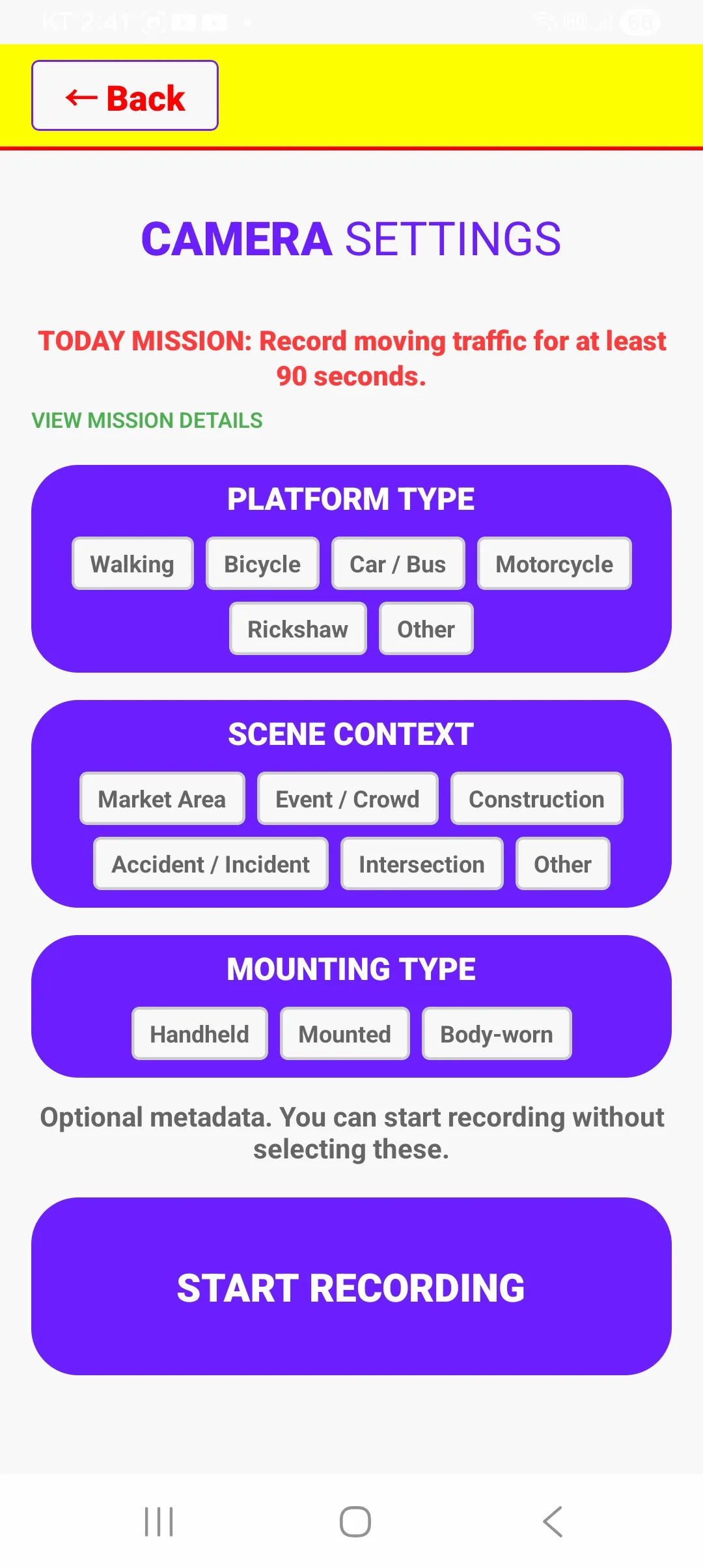
Operators receive project-defined missions and record the required workflow, scene context, capture method, task conditions, and mounting configuration before recording begins.
02
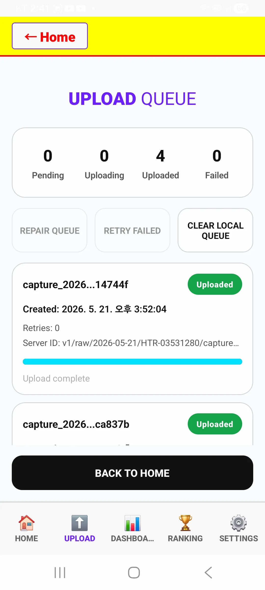
Video, capture metadata, and IMU records move through a structured upload queue with transfer status, retry handling, completeness checks, and bundle-level traceability.
03
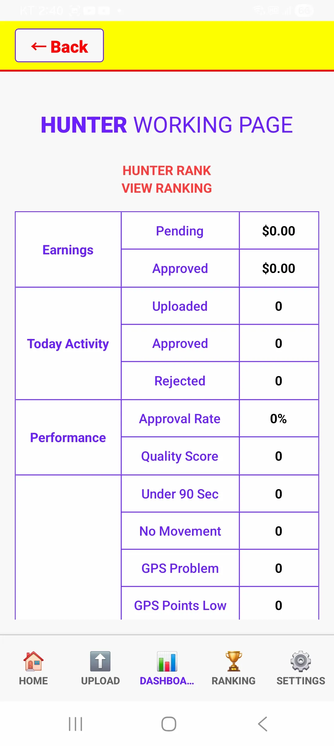
Collection activity, upload outcomes, approval status, rejection reasons, quality warnings, and recollection requirements remain visible to field operators.
04
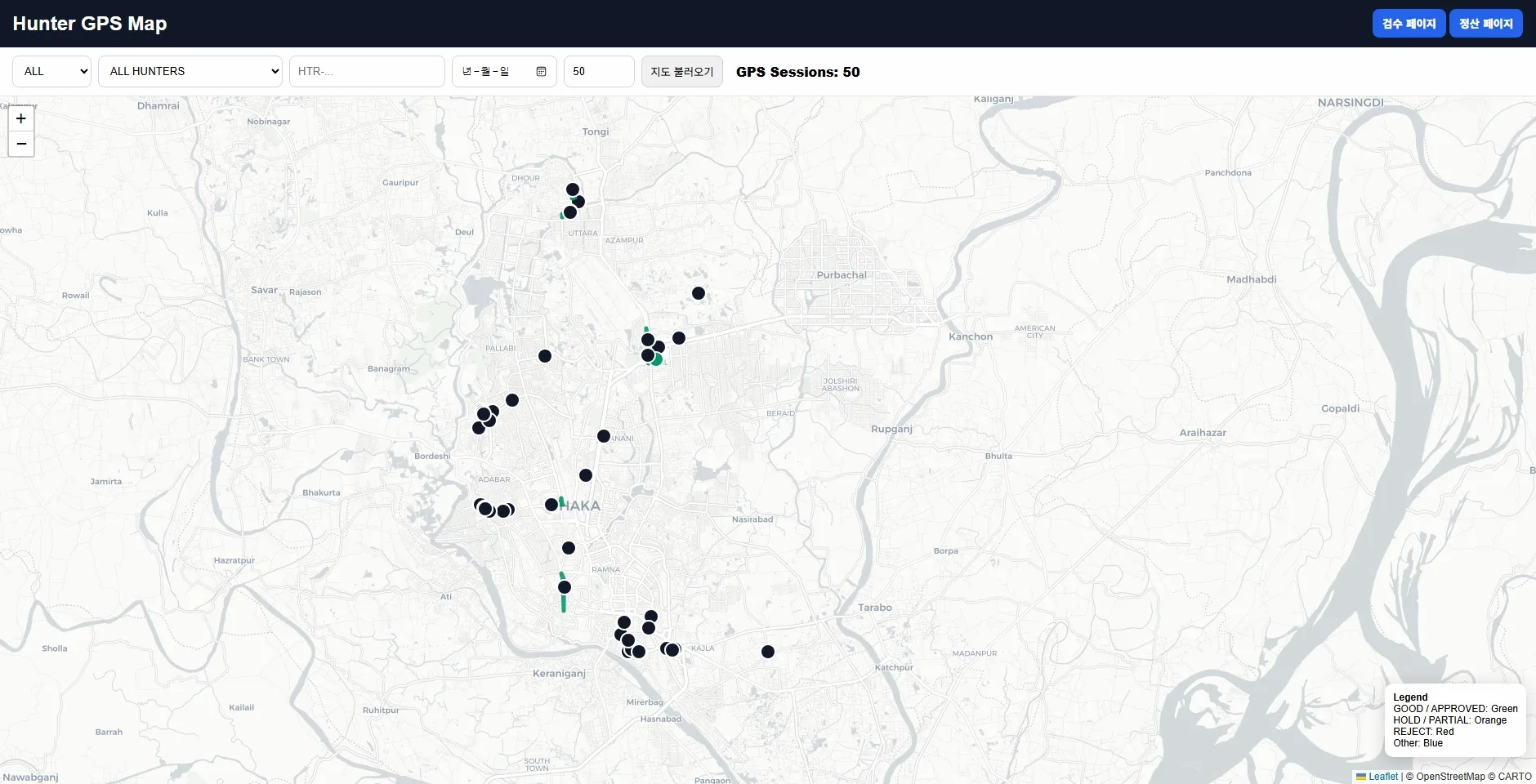
Route traces and location signals are reviewed to verify movement, continuity, distance, stop-go behavior, and compliance with the approved collection area.
05
Uploaded captures move through a defined review workflow using file integrity, metadata completeness, GPS status, sensor availability, technical warnings, and explicit approval, rejection, or recollection outcomes.
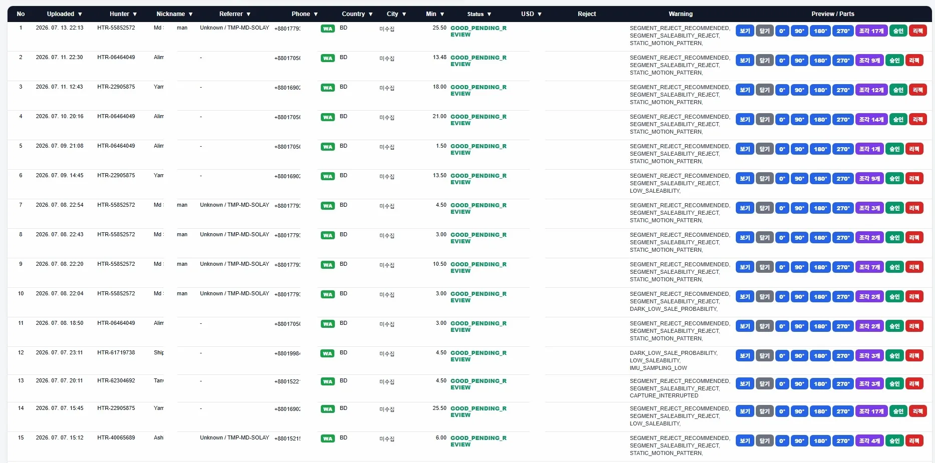
These views are taken from our current field collection, upload, sensor-validation, and quality-review workflow. Sensitive operator information, precise locations, internal identifiers, and infrastructure details are removed from the public presentation.
Public Technical Evidence
The metrics below are derived from a sanitized technical evaluation package produced from an actual field capture. They demonstrate measured IMU behavior, timestamp integrity, capture-session clock lineage, privacy controls, and buyer-facing export discipline.
Measured IMU Evidence
Measured rates are calculated from the selected continuous source interval. Requested native sensor rate does not imply the same effective delivered rate.
Synchronization and Export Controls
Traceable Technical Package
technical_package/
├── metadata_sanitized.json
├── imu_6dof_presentation_aligned.csv
├── qc_report.json
├── sync_evidence.json
├── presentation_alignment.csv
├── session_summary.pdf
├── external_delivery_manifest.csv
└── checksums_sha256.csv
Production Quality Pipeline
Captures move through explicit checks for mission compliance, file integrity, metadata and sensor consistency, scenario relevance, and final package readiness before they enter a client delivery.
01
Verify that the capture matches the assigned mission, target scene, platform, route, minimum duration, movement pattern, and recording conditions.
Mission Gate02
Verify that the required video, capture metadata, and IMU files are present, readable, complete, and linked to the correct capture bundle.
Integrity Gate03
Check identifiers, timestamps, schema versions, required fields, GPS plausibility, IMU availability, and source-to-segment relationships.
Data Gate04
Confirm that the capture is technically valid, relevant to the target scenario, correctly mapped, documented, and approved for inclusion in the delivery package.
Release GateValidation Categories
Review Outcomes
Every review outcome is retained as structured data so approval status, technical warnings, rejection reasons, and recollection requirements remain traceable before delivery.
Project-Specific Acceptance Logic
Standard checks cover bundle completeness, technical integrity, metadata consistency, and source traceability. Additional rules can be configured for scene composition, agent mix, occlusion, platform, movement, lighting, weather, route coverage, sensor availability, duplicate risk, and failure-case relevance.
Validation depth depends on device capability, sensor access, target environment, metadata requirements, and the agreed acceptance criteria. Required checks, warning thresholds, rejection conditions, and recollection rules are documented before field production begins.
Engineering Integration
Each PoC package is structured so data and ML teams can inspect media, parse metadata, verify identifier relationships, test schema compatibility, and evaluate ingestion behavior before production-scale collection begins.
01
Media, metadata, manifests, validation records, schema files, and technical documentation are separated into documented folders with defined naming conventions.
Predictable Layout02
Each video segment is connected to its metadata record, manifest entry, source capture, review status, and delivery package through stable identifiers.
Traceable Mapping03
Required fields, optional fields, data types, allowed values, relationships, and changes can be documented under an agreed schema version.
Controlled Change04
Engineering teams can test file completeness, JSON parsing, identifier joins, schema mapping, and internal ingestion behavior during the PoC.
PoC TestableExample Delivery Package
A typical PoC delivery separates video, segment-level metadata, manifests, validation outputs, schema definitions, and technical notes so engineering teams can inspect each layer without reverse-engineering the package.
poc_delivery_package/
├── video/
│   ├── SEG_00018342.mp4
│   ├── SEG_00018343.mp4
│   └── SEG_00018344.mp4
│
├── metadata/
│   ├── SEG_00018342.json
│   ├── SEG_00018343.json
│   └── SEG_00018344.json
│
├── manifests/
│   ├── delivery_manifest.jsonl
│   └── file_inventory.csv
│
├── validation/
│   ├── qc_summary.json
│   ├── approved_records.csv
│   └── rejected_records.csv
│
└── documentation/
    ├── metadata_schema.json
    ├── field_dictionary.csv
    └── delivery_notes.pdf
Clip-to-Metadata Mapping
Every delivered segment receives a stable
segment_id. The same identifier appears in the
video filename, JSON metadata record, validation output,
and delivery manifest. A separate
source_capture_id preserves lineage to the
original field recording.
Technical Evaluation
Preview or download the sample JSON to test parsing, field access, identifier mapping, schema interpretation, and compatibility with your internal tooling.
Final package structure, schema fields, naming conventions, manifest format, validation records, identifier mapping, transfer method, and ingestion-test criteria are confirmed during PoC planning and documented before production begins.
Start a Custom PoC
A custom engagement can begin with a focused feasibility pilot designed to test scenario relevance, metadata compatibility, quality criteria, and ingestion behavior before a larger production commitment.
01
Share the environment, interaction, viewpoint, sensor condition, model failure, or evaluation objective your current data does not represent well.
Initial Requirement02
We convert the requirement into a practical pilot covering field access, capture conditions, metadata fields, validation rules, package structure, timeline, and operational constraints.
Feasibility Scope03
Your team receives a compact engineering package for parsing, identifier mapping, schema review, ingestion testing, scenario evaluation, and production-planning decisions.
Technical ValidationWhat We Need to Begin
A complete procurement specification is not required for the first review. A short description of the missing condition or model weakness is enough to begin translating the problem into a feasible field-data scope.
Typical PoC Output
The PoC remains limited in scope but complete enough for engineering teams to inspect quality, test compatibility, evaluate scenario value, identify required changes, and make a controlled scale-up decision.
Controlled Scale-Up
After the pilot is reviewed, the next phase can expand only the dimensions that have demonstrated value: collection volume, locations, target interactions, metadata depth, labeling, delivery cadence, privacy treatment, or exclusivity.
Frequently Asked Questions
These answers explain how feasibility, technical scope, metadata, validation, privacy, licensing, pricing, delivery, and scale-up are handled before field production begins.
Yes. Origin Data Lab operates managed field-production capabilities in South Korea and Bangladesh across egocentric human activity, industrial and commercial workflows, household tasks, real-world mobility, and other project-defined environments. Additional locations, environments, viewpoints, platforms, and failure cases can be reviewed through a project-specific feasibility assessment.
A complete procurement specification is not required. A concise description of the model weakness, missing environment, target interaction, viewpoint, sensor condition, or evaluation objective is enough for an initial review. We then clarify field access, volume, metadata, validation, timeline, delivery, privacy, and operational constraints.
Yes. Required fields, optional fields, identifiers, data types, allowed values, folder conventions, manifests, naming rules, and output formats can be mapped to the agreed ingestion and evaluation workflow. Schema versions and field relationships are documented before production begins.
No. Our metadata framework supports more than 200 identity, technical, contextual, sensor-derived, operational, lineage, and quality-related fields. Actual availability depends on device capability, operating-system access, sensor permissions, capture platform, collection method, and the approved project scope.
Validation can cover mission compliance, required-file completeness, video integrity, duration, resolution, frame rate, codec, identifiers, timestamps, GPS plausibility, IMU availability, metadata consistency, scene relevance, duplicate risk, segment mapping, manifests, and project-defined acceptance criteria.
Review outcomes can be recorded as approved, needs review, rejected, or recollection required. Technical warnings and rejection reasons remain traceable as structured records. When the target condition is still required, a replacement capture can be requested under the agreed recollection rules.
Yes. A PoC can begin with video and structured metadata so the engineering team can first validate scenario value, technical quality, and ingestion compatibility. Annotation, labeling, scene attributes, evaluation tasks, or client-specific derived fields can then be added to the approved production scope.
Privacy treatment is defined for each engagement. Where required, the scope can include face or license-plate anonymization, review criteria, permitted use, access controls, retention, delivery conditions, and deletion requirements.
Licensing scope, permitted use, redistribution, delivery access, retention, exclusivity, geographic scope, derivative use, and production terms are documented separately for each engagement before field collection and delivery begin.
Review Legal and Transparency Information →Pricing and minimum practical scope depend on geography, field access, collection difficulty, target conditions, volume, metadata depth, validation requirements, privacy treatment, annotation, delivery structure, timeline, and exclusivity. A scoped proposal is provided after the feasibility review.
Timing depends on geography, field access, target conditions, collection volume, weather, capture platform, metadata depth, validation rules, anonymization requirements, and delivery structure. A practical schedule is proposed after the technical and operational scope is reviewed.
Transfer method, authorized access, storage duration, delivery frequency, retention period, deletion conditions, and handling of intermediate production files are agreed before production. Controls are documented according to the approved project terms.
The engineering team evaluates ingestion compatibility, schema fit, scenario relevance, metadata usefulness, validation outcomes, and model value. If technical and operational fit is confirmed, the next phase can expand volume, locations, conditions, metadata depth, labeling, delivery cadence, privacy controls, or exclusivity.
Begin with One Model Gap
Share the environment, interaction, viewpoint, sensor limitation, or failure case your current data does not represent well. We will assess feasibility and translate it into a focused capture, metadata, validation, and delivery scope.